Where are the World’s Major Shipping Lanes?
Table of Contents
Maritime shipping lanes, the lifelines of international trade, facilitate the transportation of commodities across continents. These shipping routes connect large economies and make international trade possible to run without challenges. With some lanes managing millions of tons of goods yearly, the world shipping lanes map shows how related the global economy is.
This article will discuss the busiest and most significant international shipping lanes, their relevance in worldwide trade, and their effects on logistics. We will also look at how freight forwarders for project cargo handle specialized shipments over several marine lanes.
Discover the World's Major Shipping Lanes
The English Channel
Connecting the Atlantic Ocean to the North Sea, the English Channel is among the busiest marine shipping lanes in the world. Cargo ships, ferries, and tankers typically transit this important passage, which occurs between the United Kingdom and France. Highly managed English Channel shipping channels help to guarantee safe sailing and avoid congestion in traffic.
Key Facts:
- One of the densest shipping routes, around 500 vessels pass through every day.
- Only 33.3 km wide, the Strait of Dover is the narrowest part.
- Major ports along this path are Rotterdam, Antwerp, and London.
The Panama Canal
Linking the Atlantic and Pacific Oceans, the man-made wonder known as the Panama Canal is Since its completion in 1914, the Panama Canal has been one of the most strategic shipping lanes in the world, greatly shortening journey times for ships that would otherwise have to circumnavigate South America.
Key Facts:
- The facility handles approximately 14,000 transits yearly.
- It saves ships an average of 8,000 nautical miles on their route.
- Expansion efforts and bigger vessels—known as New Panamax ships—have been able to sail through
The Strait of Hormuz
Crucially important for marine traffic, the Strait of Hormuz connects the Persian Gulf with the Arabian Sea and beyond. Global energy security depends on this small but essential pathway since it provides an entry point for Middle Eastern crude oil exports.
Key Facts:
- Around 20% of the world's crude oil supply goes via this strait.
- The strait is just 21 miles (ca. 34 km) wide at its narrowest point.
- Saudi Arabia, the UAE, and Iran are among the nations particularly dependent on this shipping route.
The Strait of Malacca
Comprising one of the most significant global shipping lanes, the Strait of Malacca links the Indian Ocean to the Pacific Ocean. Especially for container shipping and oil tankers, this area is a vital section for trade between Asia, the Middle East, and Europe.
Key Facts:
- Around 100,000 ships pass through it annually.
- The strait is barely 2.8 km wide at its narrowest point.
- Major ports in the area include Singapore, Port Klang, and Tanjung Pelepas.
The Suez Canal
Another man-made shipping path that is absolutely vital for world marine trade is the Suez Canal. Situated in Egypt, it offers the shortest maritime route between Europe and Asia; therefore, it avoids the arduous route around the African continent.
Key Facts:
- It handles 12% of global trade.
- The Ever Given incident underlined its significance when a blockade interfered with supply systems all around.
- Expansion projects aim to increase traffic capacity and efficiency.
Mapping Shipping Lanes: Maritime Traffic Around the World
It is clear by looking at a map of shipping lanes that these routes have been carefully organized and regulated to prevent congestion and maximize efficiency. Global shipping lane maps indicate the giant system of routes taken by vessels transporting anything from bulk commodities to containerized goods.
How are shipping lanes determined?
- Traffic Separation Schemes (TSS): These are enforced to control ship traffic in crowded waterways.
- Navigational Aids: Ships can remain on course with buoys, lighthouses, digital mapping systems.
- International Maritime Organization (IMO) Regulations: Guaranteeing sensible and environmentally acceptable delivery methods.
Tracking and handling ocean shipping lines depends much on technology. Through real-time vessel surveillance made possible by AIS (Automatic Identification System), safety and logistical coordination are enhanced.
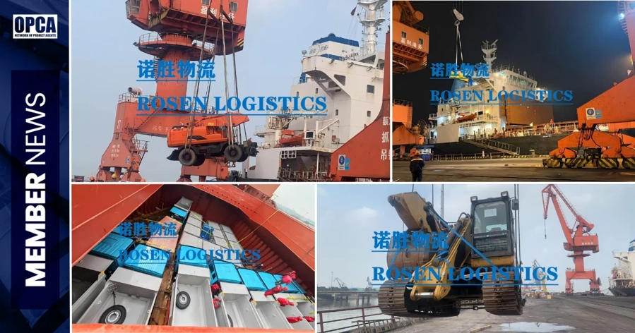
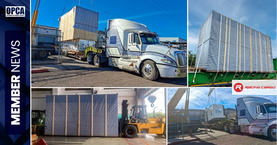
OPCA: Facilitating Seamless Project Cargo Logistics Worldwide
The need for specific logistics solutions rises as world trade keeps growing. Connecting professional freight forwarders to handle complicated and heavy cargo across the world's major shipping lanes is mostly dependent on the Overseas Project Cargo Association (OPCA).
By means of a network of dependable experts, OPCA guarantees the effective movement of project cargo over the Pacific Ocean shipping channels or the Atlantic Ocean shipping lanes. OPCA members help to enable the flawless global movement of large and high-value goods by using industry knowledge and creative logistics solutions.
Visit Project Cargo Freight Forwarders to learn about the operations of specialist freight forwarders throughout global shipping lines.